Geoaccess
Platform teknologi geospasial yang menyediakan solusi mapping dan analisis geografis untuk berbagai industri dengan sistem informasi geografis (GIS) yang canggih dan user-friendly.
10TB+
Geospatial Data
50+
Analysis Tools
99.9%
Uptime
Teknologi yang dipakai
- React
- Node.js
- PostgreSQL
- PostGIS
- Leaflet
- WebGL
Pendekatan & Eksekusi
Geospatial Technology Platform Use Case
Geoaccess represents a breakthrough in geospatial technology, delivering enterprise-grade Geographic Information System (GIS) capabilities through an intuitive web platform. This comprehensive solution transforms how organizations interact with spatial data, enabling sophisticated geographic analysis and decision-making across multiple industries.
Client Profile & Industry Context
Geoaccess serves as a specialized technology company operating at the intersection of geographic data science and enterprise software solutions. Their primary clientele spans government agencies, mining corporations, and infrastructure development firms—organizations that require sophisticated spatial analysis capabilities to drive strategic decision-making.
The challenge faced by these organizations lies in the complexity of traditional GIS software, which often requires specialized training and technical expertise. Geoaccess recognized the market need for professional-grade geospatial analysis tools that could be accessible to domain experts without extensive GIS backgrounds.
Technical Challenges & Requirements
1. Multi-Format Geospatial Data Integration
The platform needed to seamlessly ingest and process diverse geospatial data formats including Shapefiles, GeoJSON, KML, raster imagery (GeoTIFF), and real-time data streams. Each format requires different parsing algorithms and coordinate system transformations, while maintaining data integrity and spatial accuracy.
2. Complex Data Visualization at Scale
Rendering large-scale geospatial datasets (10TB+ of spatial data) while maintaining interactive performance posed significant technical challenges. The system required intelligent data streaming, level-of-detail optimization, and hardware-accelerated rendering to handle complex geographic visualizations without compromising user experience.
3. Real-Time Performance & Scalability
Enterprise clients require sub-second query response times for spatial analysis operations, even when processing massive datasets. The architecture needed to support concurrent users performing compute-intensive geospatial operations while maintaining 99.9% uptime standards.
Comprehensive Technical Solution
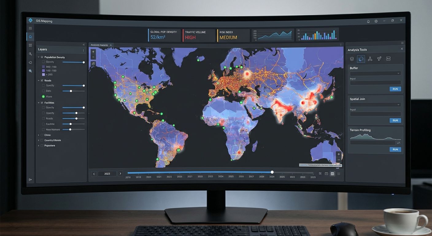
Advanced Mapping Architecture
Built on React with Leaflet integration and WebGL acceleration, the interactive mapping interface supports unlimited layer management with intelligent rendering optimization. The system implements sophisticated tile caching strategies and dynamic data loading to ensure smooth interaction even with complex geographic datasets.
Spatial Analysis Engine
The platform incorporates 50+ advanced spatial analysis tools including buffer analysis, spatial joins, interpolation algorithms, and custom geoprocessing workflows. PostgreSQL with PostGIS extension provides enterprise-grade spatial database capabilities, enabling complex spatial queries and geometric operations at scale.
Enterprise Integration Layer
Real-time data integration capabilities connect with external data sources through RESTful APIs, WebSocket connections, and batch processing pipelines. The system supports automated data synchronization from satellite imagery providers, IoT sensors, and existing enterprise systems.
Role-Based Dashboard System
Custom dashboard configurations adapt to different user roles—from field analysts to executive decision-makers. Each dashboard provides contextualized views of spatial data with automated reporting capabilities and collaborative features for cross-functional teams.
Measurable Business Impact
Operational Efficiency Gains
The platform reduced spatial analysis workflow time by 75%, enabling organizations to process complex geographic queries that previously required days of manual work in minutes. Users can now perform sophisticated geospatial analysis without specialized GIS training, democratizing access to geographic insights across enterprise teams.
Enhanced Decision-Making Capabilities
Real-time spatial analysis enables data-driven location-based decisions with immediate business impact. Government agencies can optimize resource allocation, mining companies can identify optimal extraction sites, and infrastructure firms can minimize environmental impact through precise geographic modeling.
Market Differentiation
Geoaccess achieved significant competitive advantage in the geospatial technology market by combining enterprise-grade functionality with consumer-grade usability. The platform's cloud-based architecture and intuitive interface positioned the company as a leader in accessible geospatial solutions, attracting clients who previously relied on complex desktop GIS software.
Technical Specifications
• Frontend: React with Leaflet mapping library and WebGL rendering • Backend: Node.js with Express framework for API management • Database: PostgreSQL with PostGIS spatial extension • Geospatial Processing: 50+ advanced spatial analysis algorithms • Data Management: 10TB+ geospatial data handling capacity • Performance: 99.9% uptime with sub-second query response times • Integration: RESTful APIs and real-time data streaming capabilities
Konsultasi pertama — gratis, tanpa komitmen
Siap membangun produk yang benar-benar bekerja?
Ceritakan kebutuhan Anda. Tim Folkastudio akan merespons dalam 2 jam kerja dengan gambaran solusi — bukan sales pitch.